150 Years of Soil
A Lost and Found Soil Archive at the University of Illinois Offers an Unprecedented Peak into the Prairie State’s Soils’ Past
Soil archives capture time in a bottle and enable researchers to study soil change over time. A recently re-discovered archive of soils across Illinois stretching back to 1862 offers a rare chance to probe how agriculture has changed soils in the Prairie State.
“I cannot conceive of the time when knowledge of soils will be complete,” said R. S. Smith, director of the Illinois Soil Survey, in 1928. Nearly one hundred years later, University of Illinois Urbana‐Champaign (UIUC) soil scientist Andrew Margenot can tell you that’s still true.
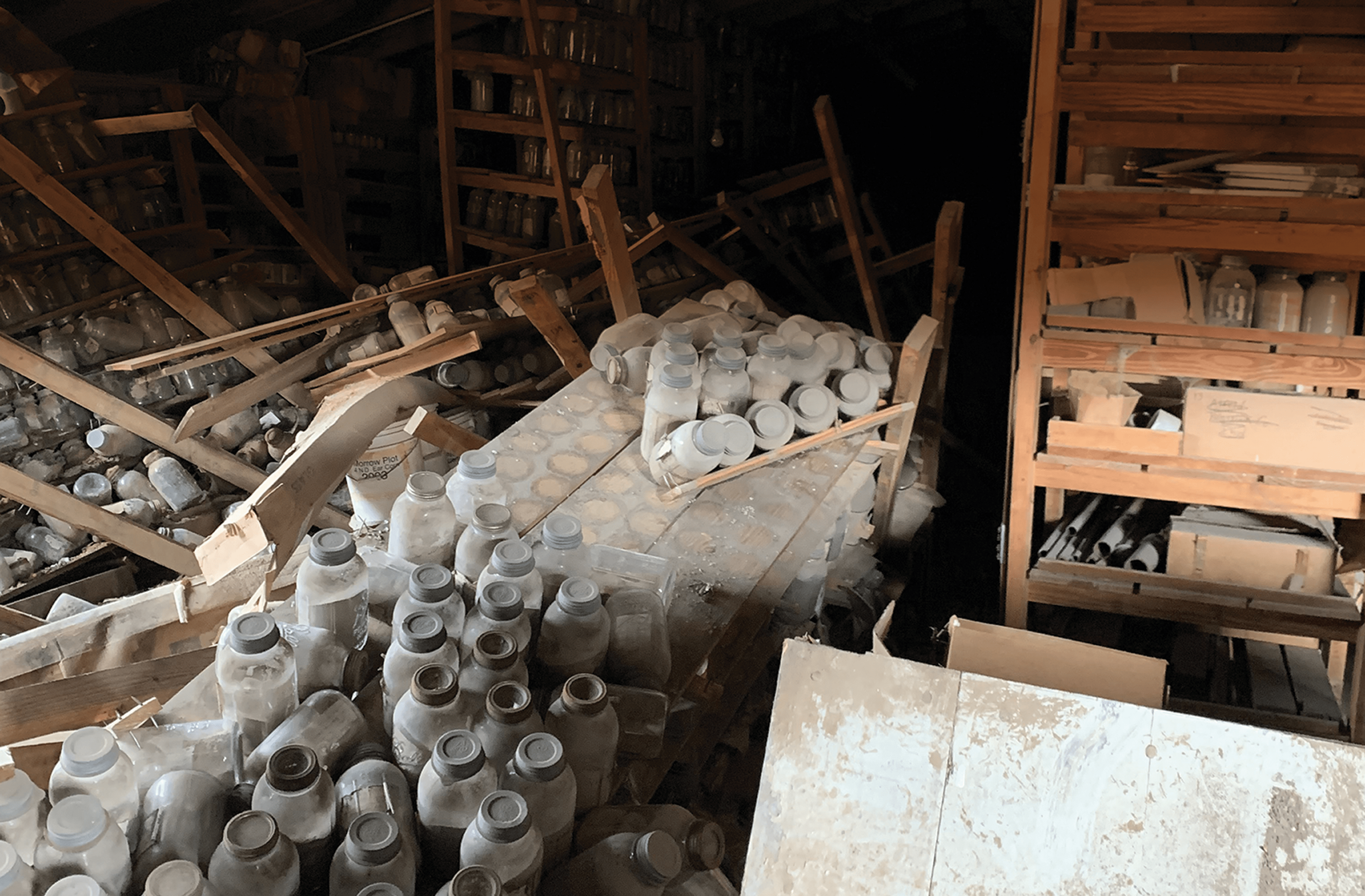
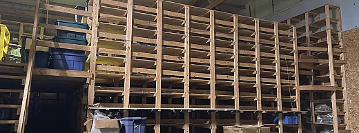
In August 2019, Margenot got a call with an unusual request: could he come inspect a building on the research farms on the university’s south campus? “There was a hole in the roof, it was full of cobwebs,” says Margenot, an ASA, CSSA, and SSSA member. But inside were collapsing wooden shelves stacked with thousands of old mason jars full of soil.
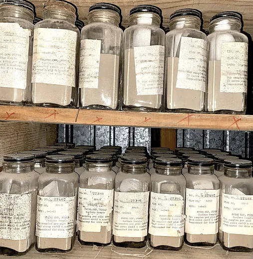
Margenot quickly realized that this was a bygone soil archive, containing soils including the original samples collected for Illinois’ soil survey initiated in the late 1800s, one of the earliest such efforts the U.S. He put on a headlamp and spent an entire Sunday combing through the jars. “Every jar was impeccably labeled, down to the day, the county, and the genetic horizons,” he says.
The oldest soil in the collection, it turned out, is from 1862. “The fact that someone took that sample of the virgin prairie when the Civil War was breaking out — that is wild to me,” Margenot says of this jaw‐dropping find, which makes the archive one of the oldest and largest in the world. Now, he and his colleagues are re‐sampling the original locations to study how soils changed across the entire state of Illinois over the last 150 years.
Sunset on the Prairies
Margenot didn’t discover the archive outright, of course. Over the years it had been added to and maintained by many researchers at UIUC, most recently by soil scientist Ted Peck who passed away in 2003. But since then, the archive fell out of use and collected dust in the out‐of‐the‐way barn.
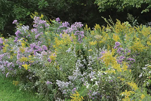
The 1862 sample predates the establishment of UIUC and was collected the year President Lincoln signed the Morrill Act permitting the creation of land‐grant colleges in the U.S. It’s also the time when the last of the prairies in Illinois were being plowed under for agriculture. “This is a state where the archive age is almost contemporary with the land use change,” Margenot says. “These samples begin when the sun was setting on the last of the prairies.”
Today, an estimated 0.01% of Illinois’ original prairies remain. That transition from 22 million acres of prairie to nearly the same amount of cropland happened within about 50 years in the late 1800s. Between 1915 and now, there has been no difference in land use change across the state according to government land use survey data, Margenot says—cropping systems dominated the landscape by that point, and still do today. As such, the archive gives researchers an unprecedented opportunity to study how agriculture has changed Illinois’ soils.
While there are debates about which state first mapped its soils, the first such effort in Illinois occurred in 1899 in Adams County, on the west edge of the state bordering the Mississippi River, Margenot says. In those days, “people were thinking about mapping soils not taxonomically, but more about what they called ‘plant food.’ They’re trying to map this to help farmers in Illinois direct inputs.”
Today, a multi‐state, ‐agency, and ‐institution effort led by the USDA National Resources Conservation Service (NRCS) called the National Cooperative Soil Survey is in charge of sampling and cataloging U.S. soils. Many of those samples end up in an archive at the survey’s laboratory in Lincoln, NE. But there aren’t many repositories of soil samples with the temporal and spatial coverage found in the Illinois archive, which contains about 8,000 samples. “Where we’re lucky is that we have the pre‐NRCS samples that give us the first half of the 20th century,” Margenot says.
“I feel like the use of anything over 80 years [old] is really rare,” says University of New Hampshire Ph.D. student Emma Bergh. A few years ago, as a researcher at the USDA‐ARS Northern Great Plains Research Laboratory near Mandan, ND, Bergh embarked on a project to investigate the use of soil archives across the global scientific literature. The Northern Great Plains Research Laboratory has a soil archive of over 5,000 samples from the many experiments conducted at the station during its one hundred‐plus years in operation. Bergh and her boss at the time, soil scientist Mark Liebig, wondered: “Who actually uses these archives? Or are we just sitting on them?”
With co‐authors including Margenot, Bergh published her review in Soil Science Society of America Journal in 2022 (https://doi.org/10.1002/saj2.20372). Overall, Bergh was surprised at how few studies make use of soil archives. “I just thought there would be more use of them, in general,” she says.
They found that most archives contain samples around 30–50 years in age, and the large majority are from North America and Western Europe. The oldest by far was the Rothamsted Sample Archive at the Rothamsted Research institute in Harpenden, England. It contains 300,000 samples, some from as early as the 1840s and most from Rothamsted’s famous long‐term field experiments, the oldest in the world (the second‐oldest, the Morrow Plots, are at the University of Illinois and are overseen by a committee chaired by Margenot). While the Illinois archive contains soils from field experiments, too, it is unique for its coverage of the total landscape, particularly soils under many different agricultural management practices.
An Unparalleled Spatial Scale
After that first Sunday, Margenot and his colleagues spent three years recovering and moving the jars into a new pole barn, cataloguing each along the way (he now has four members of his lab working on the project full‐time). While the front‐of‐jar labels were often faded or peeling, each jar also contained a label inside, most of which were likely updated and standardized sometime in the mid‐1900s, Margenot says. Each includes the soil series name, depth of sampling in inches and genetic horizon, day, month, and year collected, as well as location information of varying precision. There are multiple samples from all 102 counties in the state, with some locations like Champaign, home to UIUC and the Illinois NRCS office, unsurprisingly providing many more.
“The spatial scale is really unparalleled,” Margenot says. Illinois’ land area is about 150,000 km2, roughly the size of the country of England. Of the over 8,000 samples in the archive, Margenot describes approximately 453 pedons as “very well‐characterized,” with the researchers having high confidence of the location where each was taken, even for some of the oldest samples.
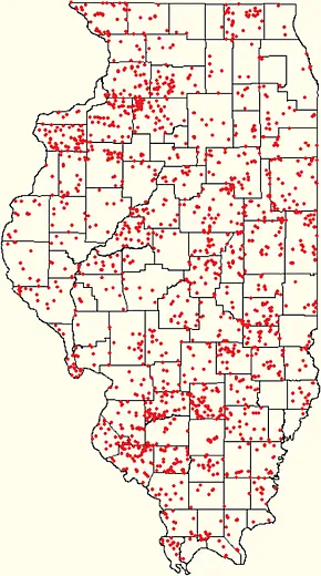
Pre‐GPS, soil samplers denoted a sample’s location by township, sections, and quadrants down to ten‐acre resolution. Later samplers noted many samples’ soil series, too, and with modern soil maps the researchers today can verify which pockets of a broader area actually contain that soil type, further narrowing down the precision. Some samples were re‐labeled with a precise location after the advent of GPS. And “some of these samples have notes like, ‘300 feet towards the oak tree from the intersection,’” Margenot explains. While the oak tree may have been cut down years ago, the researchers can use aerial imagery from as far back as the 1930s to locate the spot where it once stood, and identify where the original collectors took the sample.
The researchers can use samples that can’t be pinpointed to a precise location to investigate high level questions about large magnitude changes. But samples with high spatial precision can be used to investigate questions of practice‐sensitive changes, for example, tracking how residual phosphorus (P) built up from past. The team’s goal is to resample the same location of all 453 pedons to create a 120‐year chronosequence. The challenge now is how to access those exact locations, some a hundred or more years later.
Re‐sampling and Refining Recommendations
Most sample sites are located on privately‐owned land, be that within the middle of a field or along a property’s edges, such as by a roadside. The tricky part is getting contact information for the right folks who can let the research team on the land to collect the samples. While land‐ownership information is in public tax records, the right phone number or email address is often hard to come by. The researchers created a map (https://bit.ly/3IRIud7) for landowners and farmers to see if their property is on the sampling list, and to get in contact with the research team. Margenot also takes time to pitch the project to landowners, and not just cold call them out of the blue. Groups like the Illinois Farm Bureau (IFB), with a strong membership base of farmers across the state, have been “essential” in helping the researchers and farmers connect, he says.
“We are really well set up to communicate statewide,” says Raelynn Parmely, environmental program manager at the IFB. “If researchers need access to farmers and it makes sense to do so, we coordinate it at any opportunity.”
The soil archive has been an exciting and tangible way for farmers in the state to connect with history, Parmely says. “Some of our farmers are finding pins [on the map] on a farm that their grandparents farmed, or their great‐grandparents farmed.” Plus, research on the archive could have a real impact on management practices. “Our members want access to information that helps them implement cutting‐edge practices,” Parmely says. “They want to balance agronomic, economic, and environmental outcomes on their farms.”
"Our members want access to information that helps them implement cutting‐edge practices"
The scientists give data from each re‐sample back to the landowner or the tenant farmer, and then anonymize and strip the data of identifiers before using them for research. But even without resampling, there are so many things to learn that can be of practical use to farming with present‐day analysis of the original samples, Margenot says. One example is updates needed for the Illinois Agronomy Handbook, a compendium of agronomic information and guidance for the state. The handbook has P fertilizer recommendations broken out by regions across Illinois with differing soil supply power, a metric of the naturally occurring P in an area. However, the handbook’s map is based on estimates, not actual measurements, of how much P is stocked up in the subsoil for potential crop root access.
Margenot’s lab measured P in all samples from before 1945, which is pre‐fertilizer usage, to create an unadulterated map of soil P. “We found that in some cases, the state agronomy handbook is accurate about where there’s more or less P, and sometimes it’s completely wrong—and it’s wrong in a way that agrees with farmers. Farmers have been telling us, ‘In Central Illinois we don’t have high supply power. We have actually low,’ and the map confirms what farmers have been telling us for the last 30 years,” Margenot says. “There’s a lot of examples of [where] just looking at what we have archived can help us refine recommendations on fertilizer.”
So far, the researchers have completed sampling the original archive for total P, resurrecting pre‐1950’s methods to do so. Next they’ll use inductively coupled mass spectrometry to make total stocks maps of potassium, calcium, magnesium, iron, boron, zinc, and manganese. “The first phase is understanding and mapping stocks of every crop nutrient element,” Margenot says.
Also ongoing is sampling for soil organic and inorganic carbon (C). Despite gathering dust in the out‐of‐the‐way barn for years, most of the samples have held up “surprisingly well” for analysis thanks to being air dried, Margenot says. Had the soils been stored with more moisture, elements with a gas phase like C, nitrogen (N), or sulfur (S) could decompose and subsequent analyses would underestimate their content. The researchers expected that older samples will contain less‐than‐actual C, N, and S, because of their longer storage. Hygroscopic water films on clay soils can also allow C‐eating microbes to remain active for some time, Margenot explains.
In a 2009 study published in Journal of Environmental Quality (https://doi.org/10.2134/jeq2008.0132), a separate team of UIUC researchers measured C and N in 15 soil samples from 1901–1904 from a different archive, all which had been analyzed for the same elements in the early twentieth century when they were first collected. The measurements, 100 years apart, weren’t far off from each other, the researchers reported.
Margenot and his team are doing the same now with their dozens of samples that were measured in 1905, using contemporaneous methods and calculating the amount of C lost in storage over time. “If it’s been stored for 10, 20 years, do you hit an equilibrium of carbon loss?” Margenot’s hypothesis is the samples initially lost C when stored for the first few decades, but as microbes died off the losses plateaued. But thankfully, some 1905 analysis records still exist in the archive. “We have ways to figure out, because someone did measure these elements way back.”
An Investment for the Future
The field resampling effort began in fall 2023, with the team resampling 32 of the 453 sites on their list. The Google Map above shows their progress. They have about 80 additional sites identified with landowner permission, putting them on track by the end of 2024 to sample around 20% of their overall goal. In addition to studying how P, C, and soil micronutrients have changed, the researchers also plan to investigate how tile drainage has impacted soil morphology and classification, the emergence of soilborne pathogens, antibiotic resistance, and weed herbicide resistance. “We have trapped in the soil, like the mosquito in amber in Jurassic Park, … seeds from weed species going back to the 1800s through present,” Margenot says.
In the meantime, fundraising is underway for a new center to house the archive in climate‐controlled storage, and to ensure the archive is accessible for generations of researchers to come. The story can serve as a cautionary tale for sample archives across the sciences, Margenot says. “It’s not hard for incredible resources [like archives] to be forgotten very quickly.” Soil archives are “an investment for the future.” Collecting, storing, and caring for them now is the only way the scientists of the future can study historical environmental change. Looking back, he says, “I’m always grateful … thinking about how many people touched these jars and made a decision not to dump these.”
Dig Deeper
View the project’s Google Map of sampling sites here: https://bit.ly/3IRIud7
Read Bergh et al.’s 2022 review in Soil Science Society of America Journal here: Bergh, E. L., Calderon, F. J., Clemensen, A. K., Durso, L., Eberly, J. O., Halvorson, J. J., Jin, V. L., Margenot, A. J., Stewart, C. E., Van Pelt, S., & Liebig, M. A. (2022). Time in a bottle: Use of soil archives for understanding long‐term soil change. Soil Science Society of America Journal, 86, 520–527. https://doi.org/10.1002/saj2.20372
Text © . The authors. CC BY-NC-ND 4.0. Except where otherwise noted, images are subject to copyright. Any reuse without express permission from the copyright owner is prohibited.


