The slow drip of legacy phosphorus
Refining conservation practices across the Lake Erie watershed
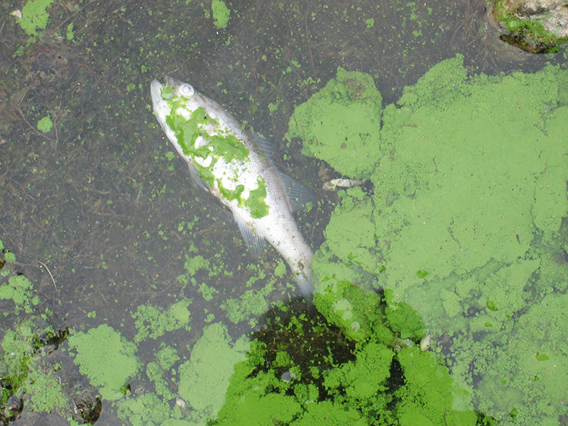
In August 2014, residents of Toledo, OH received a “do not drink order” from the public utilities office that shut down the town’s water supply for three days. The culprit fouling the municipality’s water system was an overgrowth of algae, specifically cyanobacteria, in the neighboring Lake Erie. The microscopic organisms released microcystin, a toxin that can foul water systems and cause serious human health problems.
Algal overgrowth in not uncommon in the region, but this episode culminated from a perfect storm of events. Water runoff from the surrounding agricultural land is enriched in nutrients, phosphorus and nitrogen, that drive bloom development. While the wind system typically drives the water to the east toward Cleveland, an unusual meteorological shift caused the winds to reverse, bringing the free-floating cyanobacterial bloom back toward Toledo. The bacterial bloom concentrated near the town’s water uptake valve where the level of microcystin toxin rendered the water undrinkable. Beyond the local water supply, harmful algal blooms also affect tourism, recreation, and commercial fisheries.
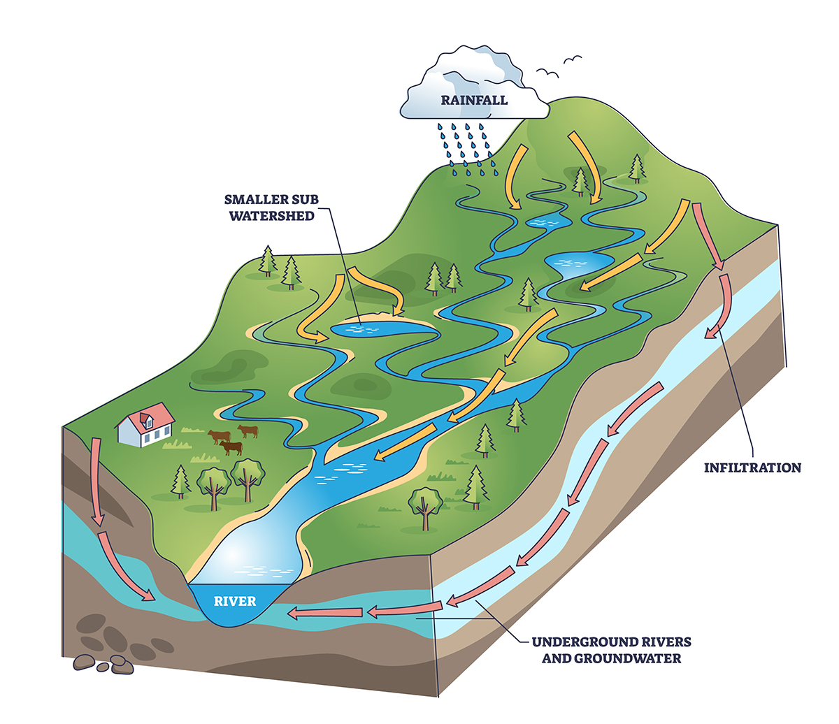
The Ohio Lake Erie Phosphorus Task Force is focused on phosphorus entering the lake. They map the various paths the nutrient takes. Pollution, in this case phosphorus, that comes from a single, identifiable source, is called a point source contribution. For Lake Erie, point source contributions come from wastewater treatment plants, sewer overflow and bypass, industrial discharge, and home sewage treatment systems. Urban and residential sources, such as lawn care fertilizer, storm water, dishwater detergent, and orthophosphate in treated water also contribute phosphorus to the lake.
By far, the largest source of phosphorus comes from non-point source pollution, which originates from a wide range of diffuse sources, such as surrounding agricultural lands. This non-point source of phosphorus has proven to be challenging to control and manage. The 4.2 million acres Maumee River drains predominantly agricultural lands in northwestern Ohio and contributes the most phosphorus to the lake, amounting to 1.2 lb/ac.
The dominant source of nutrients that fuel the harmful algal bloom are derived from synthetic and organic fertilizers applied to agricultural land to support crop production. To address these concerns, earlier environmental measures in the 1970s and 1980s focused on erosion and proper use and application of fertilizer to the land. Despite these best efforts, the situation has not improved, and municipalities on all sides of Lake Erie established the Great Lakes Water Quality Agreement in 2012. The agreement set a target to reduce springtime dissolved reactive phosphorus and total annual phosphorus load by 40% of the 2008 levels.
Sounds good, but phosphorus is tricky to manage. The nutrient is typically measured as total phosphorus, the sum of both the dissolved and particulate form of the compound. The dissolved form is reactive and leads to pollution in lake water. Management tools to target reduction of the dissolved form have been difficult to implement.
“It is not just turning a switch on and off,” says Greg LaBarge, CCA/CPAg/4R NMS and professor and field specialist with Ohio State University Extension. “It is the soluble, reactive phosphorus that is bioavailable that has been the complicating factor.”
Guidelines for Ohio, Indiana, and Michigan for corn and soybeans recommend Mehlich-3 P soil test levels between 20 and 40 ppm. However, some fields test at levels in excess of 100 ppm due to past management practices. These higher-testing fields can have higher phosphorus contributions to the surrounding water system but amount for less than 10% of the acres in the basin.
While many management approaches have been successful at limiting the application of synthetic and organic nutrients and reducing the total phosphorus flowing off the land, phosphorus can become “stuck” in the soils, forming a reservoir of this nutrient. This legacy cache of the nutrients slowly leach off the land, offering a persistent, diffuse supply of phosphorus to nearby waterways, eventually making its way into the lake and hindering water quality initiatives, like the Great Lakes Water Quality Agreement. The Maumee River carries the legacy phosphorus from a small percentage of surrounding agricultural fields to the water basin, even when only the minimal amount of new fertilizer is applied following current management practices.
“It is an issue of acute versus chronic,” LaBarge says. “We need to manage those acute applications, but legacy phosphorus is the chronic source—the constant drip, drip, drip of phosphorus leaving fields and going downstream—that requires practices focused on water management.”
One size management does not fit all
Farming practices around Lake Erie are dictated by the surrounding geomorphology, which varies across the watershed with end points marked by the southwestern and northeastern regions. The rest of the region falls along a gradient between these two extremes and provides a good approach to examine phosphorus management along the watershed.
The favorable growing season in the southwestern region (Ohio, Indiana, Michigan, and southwestern Ontario) is dominated by corn, soybean, and winter wheat, supported by commercial, inorganic fertilizer. The region relies on subsurface tile drainage to direct excess water off fields. The phosphorus applied to fields is often bound to the clay-rich soils where it is vulnerable to redox-mediated mobilization. In addition, the tile drainage system accelerates the flow of phosphorus from the fields to the waterways.
The cooler northeast region (New York and Ontario) focuses on crop rotations of winter wheat and spring grains, including corn–soybean rotations. It is dominated by artificial drainage, such as ditches and tile drains. This region is vulnerable to precipitation and erosion events during spring runoff prior to the growing season. Most fertilizer is applied after the primary seasonal erosion events, and the excess is stored in the soil.

Applying the appropriate method of conservation requires a region-specific approach. As such, a regional “toolkit” offers decision-makers a guide on how to target conservation practices that are effective and economically beneficial.
“Most practices address ways to deal with phosphorus application, but few practices will address legacy phosphorus,” says Jay Martin, professor at Ohio State University. “We mostly have to implement structural practices between the field and nearby waterways to manage runoff of legacy phosphorus.”
Creating a toolkit for conservation
The first step to controlling phosphorus runoff is the reduction in the application of fertilizer to the land. This change will slowly alter the stratification of phosphorus in the soil profile that supplies the legacy nutrient that alters the nearby watershed. The 4Rs nutrient management strategy emphasizes the application of the “right” source of nutrients at the “right” place, the “right” time, and at the “right” rate. The different rights may vary across the watershed.
Pairing the 4Rs with region-specific management practices could address the issue of mitigating legacy phosphorus leaching around the watershed. The movement of phosphorus through the ecosystem is driven by precipitation. On agricultural land, this movement can first be controlled through tillage, cover crops, and drainage.
No-till practices limit soil disturbance, but they have varied results throughout the Lake Erie watershed. No-till is often paired with limited phosphorus applications using planter placement or other low soil disturbance application tools to reduce the accumulation of the nutrient on the land’s surface. This approach may be effective in the northeastern region where the soils tend to hold onto the nutrient.
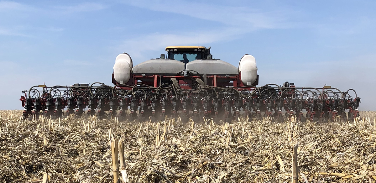
In the southwestern region, pairing no-till with phosphorus applications using planter placement or other low soil disturbance application tools could pose more harm. In this region, this practice has the potential of increasing dissolved phosphorus by inducing stratification, lessening the physical and chemical removal of reactive phosphorus, and maintaining soil pore spaces for improved drainage. The southwestern region may benefit by coupling no-till practices with subsurface drainage to limit the loss of phosphorus in surface and subsurface water and reduce water runoff.
Vegetated erosion control measures, such as cover crops and grassed waterways, provide another path to mitigate phosphorus loss. The application of these approaches also vary across the Lake Erie watershed. Vegetation is less effective during the winter and may actually lead to increased losses in the northeast; however, it can be effective with appropriate cover crop selection, especially for frost-tolerant species in the southwest.
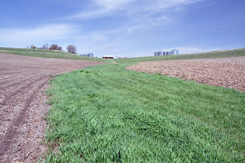
Buffer strips provide a protective zone of permanent vegetation between a farm field and waterway, slowing and filtering stormwater runoff while helping to hold soil in place. Buffer strips also have been found to be effective, particularly in the northern region of the watershed, at reducing phosphorus from reaching the lake, but these features can be more expensive and labor intensive.
The construction of earthen embankments, such as water and sediment control basins, across the slope of a drainage pattern can control the stage, discharge, distribution, delivery, or direction of water flow in open channels. These human-made structures also reduce gully erosion and trap sediment to manage and reduce water runoff. Although not designed to control nutrient flow, sediment control structures have been found to reduce phosphorus movement from agricultural fields. These structures also have been proven to be more effective across the Lake Erie watershed than tillage practice or cover crops.
Bring parties together for conservation
The problem of legacy phosphorus is the persistent, although minor, leak of the nutrient off a wide swath of land. While each farmer plays a role in addressing this problem, a large-scale approach may miss the targeted regions where legacy phosphorus is high.
Public–private partnerships are arrangements where the resources, responsibilities, risks, and rewards are shared between the participants in pursuit of a mutually agreed upon objective. This partnership often pairs agricultural retailers with farmers to address big picture issues, such as legacy phosphorus. A 2021 study found these partnerships offer a natural channel to share information on how to manage nutrient runoff.
Similar to the 4R program, public–private partnerships address this issue in a more targeted way. The proportion of fields that could benefit from the array of 4R practices is relatively large compared with the proportion of fields with elevated phosphorus concentrations, which require mitigation through other means, including edge-of-field practices. By recruiting farms with legacy phosphorus concerns into public–private partnerships, policies can be developed that address phosphorus loading rates and control the impact of legacy phosphorus.
Conservation practices must balance environmental benefits with crop production and profitability. This requires an analysis of the cost to the farmer to implement the appropriate practice to achieve the environmental targets of phosphorus reduction from their fields.
In a 2021 paper published in the Journal of Environmental Quality, Merrin Macrae, a professor at the University of Waterloo, argues for a regionally tailored, adaptive, and cost-conscious conservation practice for the Lake Erie watershed. The proposed plan consists of five steps.
phosphorus management that incorporates an improved understanding of the interactions, heterogeneity, and scale dependence of landscape and climate factors on phosphorus loss across the watershed;
region-specific guidance through improved conservation practice catalogues or fertilizer recommendations;
region-specific field trials linked to water quality monitoring to quantify the efficacy of conservation practices for the different phosphorus management regions and to improve computer model output;
clear communication to ensure producers are using the right practices in the right places; and
adaptive management framework to detect, assess, and mitigate trade-offs in the implementation of conservation practices in order to foster collaboration and the sharing of experiences.
“There are programs out there that offset the costs and incentivize the practices that would need to be implemented to reduce phosphorus coming off fields,” Martin says.
Martin points to programs, including H2Ohio, Natural Resources Conservation Service, Soil and Water Conservation Districts, and state extension offices, that work on land, water, and air conservation issues. These organizations bring the latest practices to farmers in their fields and find resources to help pay for many of the upgrades that are needed to improve the flow of water and filtration in order to limit and control legacy phosphorus on the surrounding watershed.
Refining the conservation practices across this highly variable region can target recommendations that allow farmers to make strategic decisions that are beneficial to their bottom line and ultimately lead to improved water quality. Trust will be strengthened by bringing all partners—farmers, managers, and scientists—together to the table to address the flow of legacy phosphorus from the watershed into Lake Erie.
“Things are going in the right direction for agriculture practices and management,” LaBarge says. “We are reducing [the concentration of reactive phosphorus in] soil test levels over time, but it takes a long time to reduce phosphorus levels overall.”
Dig deeper
This article is part of a special collection, "Legacy phosphorus: 4R nutrient stewardship, regional conservation, and collaborative, adaptive management." Check out the research papers mentioned in this article:
Brooker, M.R., D'Ambrosio, J., Jones, M.M.L., Kalcic, M., King, K.W., LaBarge, G., … & Martin, J.F. (2021). A public-private partnership to locate fields for implementation and monitoring of best management practices to treat legacy phosphorus. Frontiers in Sustainable Food Systems, 5, 742817. https://doi.org/10.3389/fsufs.2021.742817
Macrae, M., Jarvie, H., Brouwer, R., Gunn, G., Reid, K., Joosse, P., … & Zwonitzer, M. (2021). One size does not fit all: Toward regional conservation practice guidance to reduce phosphorus loss risk in the Lake Erie watershed. Journal of Environmental Quality, 50, 529–546. https://doi.org/10.1002/jeq2.20218
If you’re interested in this topic, you may also want to check out the training series, “Phosphorus Removal Structures: Design, Construction, and Management,” for which you can earn up to 6 CEUs.
Self-study CEU quiz
Earn 1 CEU in Soil & Water Management by taking the quiz for the article. For your convenience, the quiz is printed below. The CEU can be purchased individually, or you can access as part of your Online Classroom Subscription.
What toxin was released by cyanobacteria during the 2014 Toledo, OH water crisis?
a. Nitrosamine.
b. Microcystin.
c. Glyphosate.
d. Ammonia.
Which river contributes the most phosphorus to Lake Erie?
a. Cuyahoga River.
b. Maumee River.
c. Detroit River.
d. Sandusky River.
What percentage reduction in phosphorus was targeted in the 2012 Great Lakes Water Quality Agreement?
a. 20% from 2010 levels.
b 25% from 2005 levels.
c. 40% from 2008 levels.
d. 50% from 2012 levels.
Which type of pollution is the largest source of phosphorus entering Lake Erie?
a. Point source pollution.
b. Industrial discharge.
c. Non-point source pollution.
d. Urban wastewater.
In the southwestern Lake Erie watershed region, if producers are practicing no-till, the article recommends pairing this practice with drainage systems to limit the loss of phosphorus in surface and subsurface water and reduce water runoff.
a. True.
b. False.
6. Soil test recommendations for corn and soybeans in Ohio, Indiana, and Michigan suggest Mehlich-3 phosphorus levels between
a. 5 and 15 ppm.
b. 20 and 40 ppm.
c. 50 and 70 ppm.
d. 80 and 100 ppm.
7. Which factor makes dissolved phosphorus especially problematic in Lake Erie?
a. It binds strongly to soil particles.
b. It is non-reactive in water.
c. It evaporates quickly.
d. It is readily bioavailable to algae.
8. Across the Lake Erie watershed, cover crops have been found to be more effective as reducing phosphorus movement than sediment control basins.
a. True.
b. False.
9. The article mentions that buffer strips are particularly effective in which part of the Lake Erie watershed?
a. Northern region
b. Southern region
c. Central region.
d. Western region.
10. According to Merrin Macrae’s five-step plan, which of the following is included as a key component of phosphorus management?
a. Region-specific field trials linked to water quality monitoring.
b. Abandoning corn–soybean rotations.
c. Replacing synthetic fertilizer with only manure.
d. Prohibiting tile drainage across the watershed.
Text © . The authors. CC BY-NC-ND 4.0. Except where otherwise noted, images are subject to copyright. Any reuse without express permission from the copyright owner is prohibited.

